The Malaysian Meteorological Department released a weather alert on Thursday covering thunderstorms, torrential rainfall and strong wind conditions expected to sweep across six Malaysian states through the early hours of Friday morning, extending until 3 am. Residents and authorities in the affected regions have been urged to remain vigilant and take precautionary measures as the atmospheric disturbance moves across both the northern and east coast of Peninsular Malaysia.
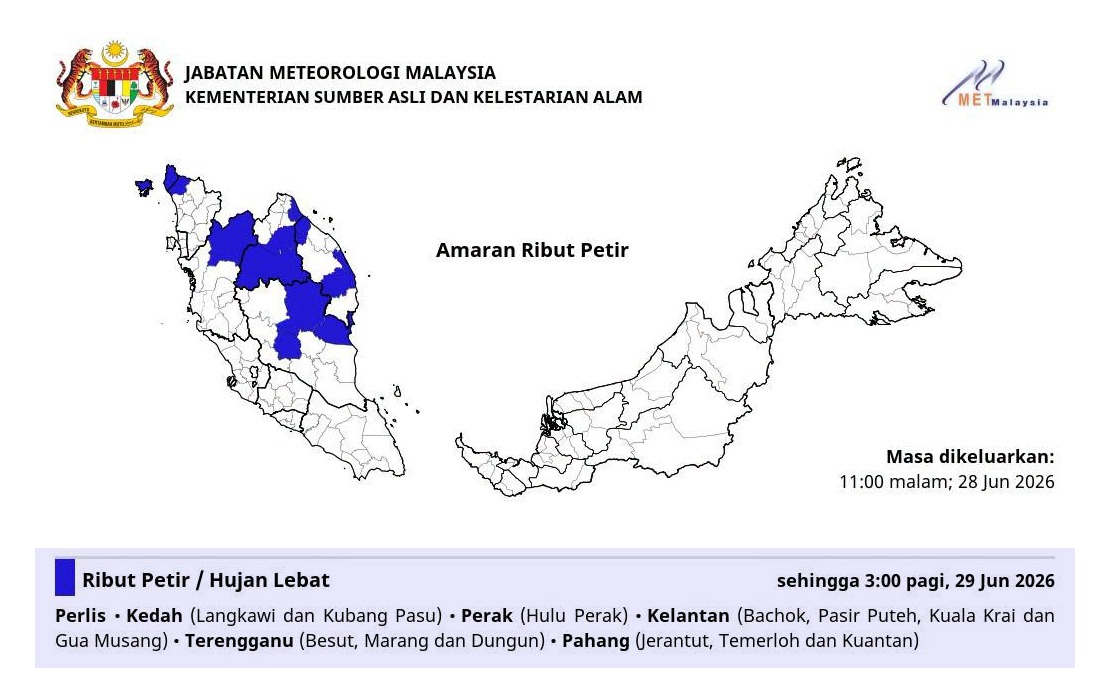
The alert encompasses a significant geographic spread across the country's northern and eastern territories. In the north, Perlis faces the full brunt of the warning, whilst Kedah's Langkawi and Kubang Pasu districts are flagged for heightened weather activity. Further south, Perak's Hulu Perak region is included in the alert zone, indicating that the weather system's influence extends well into the central regions of the peninsula. This geographical pattern suggests a consolidated weather front moving systematically across the northern corridor.
The east coast, typically vulnerable to monsoon-related weather systems, has also been placed on alert. In Kelantan, the warning applies to four districts: Bachok, Pasir Puteh, Kuala Krai and Gua Musang, covering both coastal and inland areas. This multi-district advisory suggests meteorologists expect variable intensity across the state, with different regions experiencing different severity levels. The inclusion of Gua Musang, located inland near the central mountain range, points to the possibility of orographic effects amplifying rainfall in higher terrain.
Terengganu's three coastal and near-coastal districts have similarly been included in the warning. Besut in the north, Marang in the central coast, and Dungun in the south form a coastal corridor under alert, suggesting that maritime moisture and sea-breeze interactions could intensify convective activity along these regions. For maritime users and fishing communities, such warnings are particularly significant given the correlation between thunderstorm activity and hazardous sea conditions.
Pahang, the largest state on the peninsula, sees its warning focused on three districts: Jerantut in the northwest, Temerloh in the central region, and Kuantan on the east coast. The spread across inland and coastal areas within a single state reflects the expansive nature of the weather system, potentially covering hundreds of kilometres. These three districts encompassing mountainous terrain, agricultural lands, and urban centres represent diverse topographical and demographic environments where weather impacts vary considerably.
Thunderstorm warnings carry specific hazard implications beyond simple rain. The combination of heavy precipitation, strong winds and lightning creates compounded risks for outdoor activities, transportation networks and infrastructure. Heavy rain in these quantities can overwhelm drainage systems, particularly in low-lying areas and urban settlements, leading to flash flooding. Strong winds accompanying such systems pose dangers to structures, vegetation and outdoor objects. Lightning activity, whilst often overlooked in public discourse, represents a significant mortality and injury risk during thunderstorm events.
For residents in these six states, the advisory necessitates practical precautions. Those in flood-prone areas should consider moving valuables to higher levels and monitoring water levels. Motorists should exercise extreme caution, particularly on highways and in areas with poor visibility. Outdoor events scheduled for the evening hours may need postponement or relocation indoors. Agricultural workers and plantation operators should secure loose materials and equipment that could be damaged or displaced by strong gusts. Fishing communities should avoid venturing into waters during peak storm hours.
From an infrastructure perspective, local authorities and utility companies typically activate heightened monitoring protocols when such warnings are issued. Power distribution networks become particular concerns during thunderstorm activity, with lightning strikes posing risks to electrical systems. Water supply authorities monitor dam levels and flood control installations. Roads and drainage departments prepare emergency response teams for potential flooding situations. Schools and public institutions may adjust operating schedules based on evolving weather conditions.
The three-hour window until 3 am represents the predicted duration of the most intense weather activity, though atmospheric conditions typically do not terminate abruptly at a specified time. Rather, the warning reflects meteorological confidence intervals and modelling predictions for when dangerous conditions are most probable. Residents should remain cautious even after the official warning period concludes, as residual moisture and instability may persist into the morning hours with occasional squalls.
Such regional weather alerts have become increasingly frequent across Malaysia during transitional monsoon periods and pre-monsoon seasons. The geographic clustering of warnings across northern and east coast states suggests specific atmospheric circulation patterns, potentially related to inter-monsoonal transitional conditions or tropical disturbances. Understanding these patterns helps communities build resilience and preparedness for recurring weather challenges.