Japan's meteorological authorities issued an urgent alert on Friday as the country prepared to face the simultaneous approach of two powerful typhoons, with Typhoon Higos expected to make landfall the following day and Mekkhala already threatening southwestern coastal regions. The dual weather systems represent a compounding natural disaster scenario for the island nation, which faces particular vulnerability to typhoons given its geography and monsoon exposure. Heavy rainfall was already pummelling western and eastern portions of the country, with no relief expected until the systems weakened and transitioned into extratropical cyclones—a process the Japan Meteorological Agency cautioned could still pose significant hazards even as wind speeds diminished.
The scale of the immediate threat became evident from evacuation figures released by the Fire and Disaster Management Agency, which reported that more than 2 million residents across 13 prefectures in the Kinki and Kyushu regions had been placed under evacuation orders by 7 am local time on Friday. This mass displacement underscores the severity of flooding and landslide risks that forecasters identified, particularly in areas already saturated by preceding rainfall. The evacuation orders represented precautionary measures aimed at moving vulnerable populations away from zones where sudden water surge, terrain collapse, and debris flows posed the greatest danger during the storm passage.
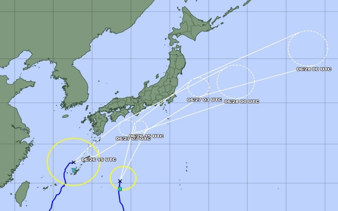
The Amami region in Kagoshima Prefecture in southwestern Japan experienced direct typhoon impact on Friday as Mekkhala approached, with the system expected to drift toward the Kanto region by Saturday. Simultaneously, Typhoon Higos was tracking northward from the Pacific, positioning itself to reach Japan's southern coast and deliver substantial precipitation across the central and eastern portions of the archipelago. The convergence of these two systems created a meteorologically complex situation in which rainfall from one typhoon could overlap with moisture delivery from the other, potentially amplifying precipitation totals in certain regions and extending the duration of severe weather.
Accumulated rainfall measurements from the preceding days demonstrated the intensity of atmospheric moisture being drawn toward Japan's surface. Between Tuesday and Friday morning, Goto in Nagasaki Prefecture recorded 600 millimetres of rain, while Aso in Kumamoto Prefecture and Ureshino in Saga Prefecture each experienced more than 500 millimetres. These figures, measured over a four-day period, indicated that soil saturation had reached critical levels, leaving terrain vulnerable to failure when additional rainfall from the approaching typhoons arrived. Ground already oversaturated from recent weather systems becomes increasingly susceptible to sudden collapse, as water pressure within soil layers reduces friction and cohesion.
The severity of landslide conditions became immediately apparent when authorities in Seika, Kyoto Prefecture, issued a level 5 emergency safety alert—the highest warning classification—after a landslide occurred on Friday morning. This incident served as a concrete demonstration of how rapidly localized geology could fail under saturated conditions, and foreshadowed the potential for similar failures elsewhere as the twin typhoon systems delivered their main precipitation bands. Emergency management officials recognized that the combination of antecedent moisture and incoming heavy rain created optimal conditions for terrain instability across multiple prefectures.
Weather forecasters anticipated intensifying rainfall across the Tokai and Kanto regions through Saturday as Typhoon Higos tracked northward off the southern coast while Mekkhala continued its approach. The Tokai region faced projections of up to 300 millimetres of rain by Saturday noon, while the Kanto-Koshin region was expected to receive up to 150 millimetres. These forecasted amounts, concentrated over a compressed timeframe, posed significant runoff challenges for drainage systems and water management infrastructure already challenged by preceding rainfall. Rivers and drainage channels in these regions risked exceeding their channel capacity, potentially causing widespread inundation of agricultural lands, transportation corridors, and populated areas in low-lying zones.
Meteorological data released on Friday morning indicated that Typhoon Mekkhala was positioned northeast of Kume Island in Okinawa Prefecture, advancing northeastward at a forward speed of 15 kilometres per hour. This translation speed suggested the system would maintain steady progress toward more northerly latitudes, bringing organized convection and moisture into the atmospheric column above central and eastern Japan. Okinawa Prefecture itself faced warnings of strong storms as the system transited the region, with potential for localized severe weather including gusty winds and concentrated rainfall bands embedded within the broader typhoon circulation.
The dual-typhoon scenario presented particular forecasting and emergency management challenges because conventional single-storm preparation and response protocols required adaptation to accommodate two concurrent systems with different tracks, intensities, and timing. Residents and officials in regions positioned to experience weather from both typhoons faced the prospect of extended periods of severe conditions, with potential gaps between the two systems offering only partial respite before the second wave of impacts arrived. This extended threat period complicated resource mobilization and recovery efforts, as personnel and equipment remained committed to response operations across a prolonged timeframe rather than concentrating response activities into a shorter, more intense period.
For Malaysia and Southeast Asia, Japan's typhoon situation underscores the regional significance of tropical cyclone activity during peak monsoon seasons, when atmospheric instability and warm ocean temperatures create favorable conditions for system development and intensification. While Malaysia's geographic position places it somewhat outside typical typhoon recurvature zones, the broader Indo-Pacific cyclone circulation patterns that spawn systems affecting Japan also influence weather across Southeast Asia. Enhanced monsoon troughs and moisture convergence zones triggered by major typhoon activity in temperate waters can indirectly influence precipitation patterns across Malaysia and neighboring nations through atmospheric teleconnections, particularly during June and July when both the Southwest and Northeast monsoon transitions occur.