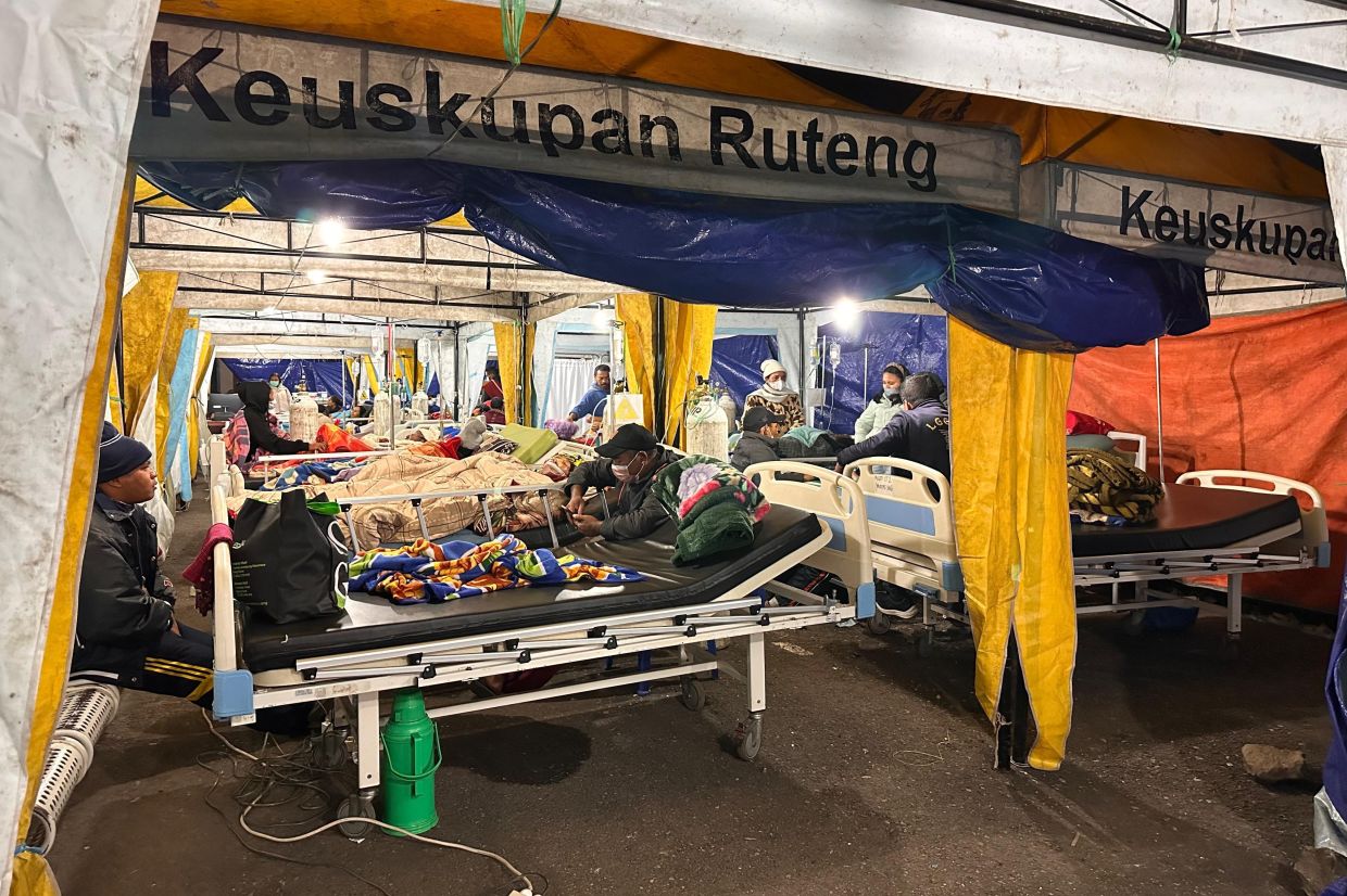
Indonesia's Flores Island faced an unrelenting seismic assault on Sunday following a powerful magnitude 7.7 earthquake that struck in the early morning hours, leaving at least 53 people dead and displacing thousands of residents to emergency shelters. The devastating event, centred in waters approximately 30 kilometres from the coastal town of Mbay in Nagekeo district, unleashed a cascade of nearly 1,000 aftershocks that continued to unsettle the region throughout the day, according to authorities monitoring seismic activity in this geologically volatile area of eastern Indonesia.
The initial earthquake struck at 4.58 am local time with its epicentre located 15 kilometres beneath the ocean floor, triggering immediate tsunami warnings across the region. The Meteorology, Climatology and Geophysics Agency (BMKG) issued alerts but subsequently lifted the warning at 7.31 am after careful sea-level monitoring indicated that no significant tidal surges were developing. However, the relentless sequence of aftershocks—995 had been formally recorded by 3 pm Sunday according to Abdul Muhari, Deputy for Prevention at the National Disaster Management Agency (BNPB)—continued to rattle nerves among the affected population, even though most remained below the threshold of human perception.
The human toll reflected the quake's devastating reach across seven regencies and municipalities in the region. Beyond the 53 confirmed fatalities, 135 residents sustained injuries requiring medical attention, while authorities worked systematically to account for all residents in the affected zones. Significantly, the National Search and Rescue Agency (Basarnas) reported no missing persons after conducting preliminary checks, suggesting that initial damage assessments had captured the scope of the disaster, though officials cautioned that casualty figures remained subject to revision as verification procedures continued through the second day of emergency response operations.
The psychological dimension of the disaster extended beyond the immediate physical destruction. Many residents chose to remain at evacuation centres even as rescue efforts progressed, driven by deeply rooted trauma from the catastrophic 1992 Flores earthquake and subsequent tsunami that claimed thousands of lives and left indelible scars on the community's collective memory. This historical context shaped behavioural responses to the current crisis, with approximately 9,290 people occupying shelters as of midnight Saturday, according to preliminary counts. The reluctance to return home reflected not merely rational caution regarding structural safety but also the enduring psychological vulnerability of a population that had experienced nature's fury at unprecedented scales within living memory.
The physical landscape bore testimony to the earthquake's destructive capacity. Roads suffered significant damage, with landslides blocking critical supply routes—particularly in Reok, Manggarai—though authorities reported that key thoroughfares had been reopened to accommodate fuel tanker trucks essential for maintaining operations. Power infrastructure sustained widespread disruption, with blackouts cascading across multiple communities until restoration efforts gradually returned electricity to several affected zones. These infrastructure challenges complicated humanitarian operations, forcing responders to coordinate logistics under constrained conditions while attempting to deliver food, water, and medical supplies to displaced populations.
To manage the crisis, Indonesian disaster officials established a coordinated response architecture spanning multiple locations. The BNPB activated regional response posts in both Labuan Bajo and Maumere, strategically positioned to manage the affected territories in eastern Flores. Supporting logistics nodes were established in Jakarta, the national capital, as well as in the two regional hubs, creating supply pipelines to channel relief materials, specialized equipment, and personnel into the stricken areas. This multi-tiered deployment structure reflected lessons learned from previous disasters, enabling a more efficient distribution system than could be achieved through single-point coordination.
Air support capabilities were mobilized to supplement ground-based relief efforts. Aircraft and helicopters were positioned on standby status, ready for immediate deployment should rescue and recovery operations require aerial transport of supplies, evacuation of injured persons, or delivery of specialized equipment to areas rendered inaccessible by road damage. This aviation reserve represented a critical backup system given Flores's geographic isolation and the potential for further deterioration of infrastructure caused by ongoing seismic activity or secondary hazards such as landslides triggered by the initial shock.
For Southeast Asian observers, the Flores earthquake serves as a sobering reminder of the region's extraordinary exposure to seismic hazards and the recurring vulnerability of population centres built along active tectonic zones. Indonesia itself straddles the Pacific Ring of Fire, making it one of the world's most earthquake-prone nations, yet each major event reveals persistent challenges in building resilience despite decades of experience with natural disasters. The pattern of nearly 1,000 aftershocks following the primary quake exemplifies the complex geophysical processes that can extend disaster impacts across extended timeframes, complicating recovery efforts and prolonging psychological distress among affected communities.
The immediate priority for Indonesian authorities centered on victim assistance, with emergency teams distributing essential provisions and undertaking systematic assessments of structural damage to determine which homes remained safe for habitation. This dual focus on humanitarian response and damage evaluation would shape the trajectory of recovery operations, determining both the timeline for population return and the scope of reconstruction requirements. Officials indicated that this intensive phase would extend well beyond the initial 48 hours as complete situational awareness developed.
The unfolding crisis underscores the humanitarian costs of living in seismically active regions and the permanent state of preparedness required of governments and communities in such zones. While modern seismic monitoring has dramatically improved early warning capabilities—evident in BMKG's rapid assessment of tsunami risk—the underlying geological realities remain immutable. Indonesia's experience with the Flores earthquake and its aftermath will likely inform regional disaster management strategies across Southeast Asia, where similar tectonic settings create comparable risks for neighbouring countries including the Philippines and Papua New Guinea.

